 Renaturation project with small settlements along agro-ecological and permacultural principles
Region Almaty / Kasachstan
Introduction
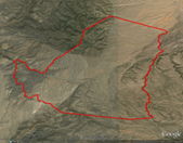
This project "Boguty" is first and foremost a renaturation venture of a very dry semi-desert steppe area of about 5000ha, roughly situated 150km east of Almaty / Kasachstan.
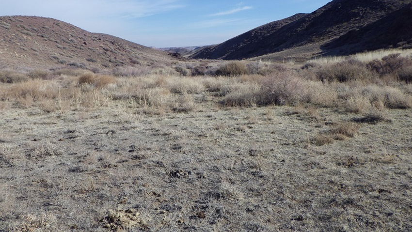
Formative and characteristic of the site is an impressively beautiful changing landscape of soft, hilly, dry grass steppe areas on one side and abrasively rocky mountainous structures with steep canyons on the other side. Vegetation is dominated by xerophytic plants, dry steppe grass alternating with a rocky landscape. Significant are also various erosion ditches which are being formed, especially in many lower situated areas, within the typical and dominant eolian silt deposits. These erosion structures indicate temporary high surface water runoff events (i.e. heavy rainfalls and/or snow melting periods).
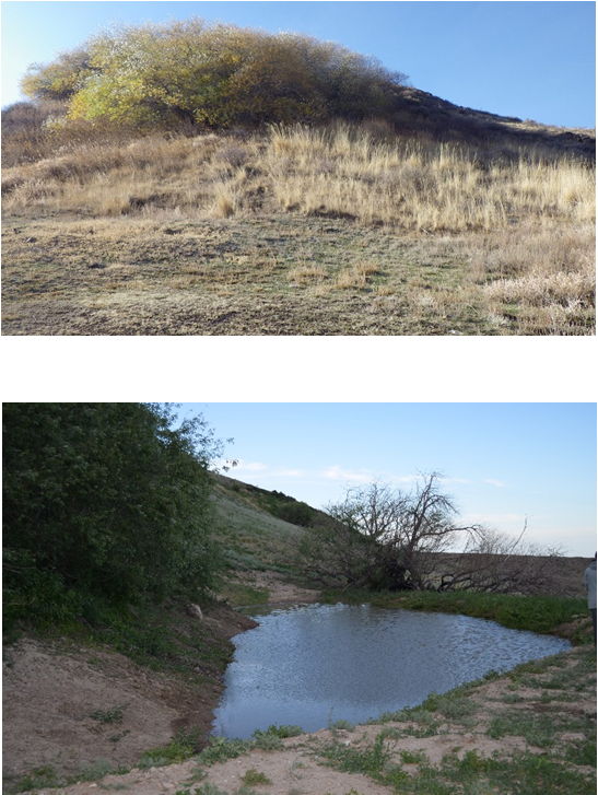
There are very few special natural geological and climatic zones where there is an abundance of water which in turn seems to have a huge impact on the existent vegetation in these areas. Many trees, bushes, shrubs, herbs as well as as diverse annual plants grow in these places which seem otherwise absent in the surrounding landscape. These places seem to be little oases in a semi-desert like surrounding which provides them with a "magical" and very particular appearance.
These phenomena seem to indicate that one of the large factors for this extremely scant landscape is the lack of water:
A degraded water household can be regarded as a dominant cause for a depleted landscape.
Nonetheless, the factors and conditions leading to such a scarce and rough landscape are manifold and complex: many are of natural, others of anthropogenic origin, some of both. This project will try to analyse all the factors that might play a role leading to the conditions we are presently confronted with as well as indicating their - sometimes extremely complex - interactions.
By no means do we claim to be able to analyse or understand these intricate ecological relationships between biology, climate, topography, history, geology, etc. entirely. This would only be arrogant, pretentious and frivolous. Nonetheless, we can, should and will try to understand as much as possible in order to minimise the possibility for mistakes which can never be ruled out
Our knowledge and understanding should first and foremost derive from an intensive communication with "nature" and the actual site conditions.
Theoretical knowledge should only have a supporting character in regards to this project but will never be able to replace an active communication with nature itself.
In other words the project should be conceived and realised with a respectful attitude towards the site and its existing inhabitants. These inhabitants include all living organisms; may they be animals, plants, fungi - visible or not !
The main renaturation strategy is as follows:
- special places must be defined on the site with favourable natural conditions in terms of geology, preconditions in water-household and potential for nature to develop biodiversity.
- these favourable natural conditions will have to be intensified and thereby improved in a catalytic manner, while the existing situation for vegetation will be kept as such, which means a non-invasive approach to existing ecological hot spots.
- the interventions should be undertaken with the minimum effort and maximum effect.
- the disrupted water household should be restored to form a basis for life (we say that 70% percent of the work is done when the water household is revived).
- regionally adapted, autochtone and thus suitable plants should be (re-)introduced adhering to natural succession cycles.
- all work should be carried out in relatively small areas, well observed, studied and documented
- mistakes should not be repeated, successful strategies implemented and constantly improved on larger areas, documentation should continue all the time.
Existing Conditions
Location
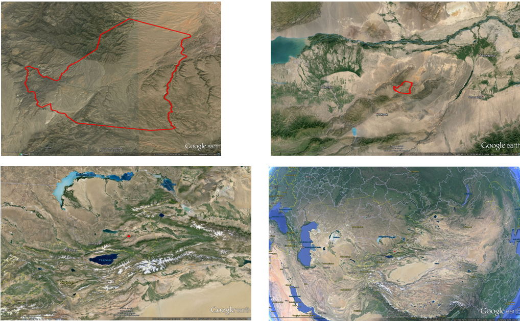
The site is situated about 150km east of Almaty / former capital city in the southeast of the Republic of Kasachstan, about 30km south of the river Ily, about 300km south-southeast of the huge Balkhash lake, roughly 130km west of the boarder to China and 80km north of the boarder to Kirgistan in Central Asia.
In geomorphological terms this area is a low mountain range called "Boguty" in the mountains of Trans-Ili Alatau.
Topography / Geology / Soils
The project area amounts to about 5000ha, its lowest points are at about +900m (east and west), the highest point at about +1600m above sea level (north). This implies a total height difference of ca. 700m.
According to the locally produced geological surveys and expertises the presence of poor soils, extreme dryness and the problem of high mineral concentration (salinization of ground water and soils) is stressed. Generally the surveys point out that the land is only good for extensive animal farming with poor yields, a general lack of water as well as insufficient nutrients.
Climate
The area is of extremely continental character with high temperature differences between summer-winter as well as day-night. The air is very dry.
The climate is mostly arid, especially throughout the summer months, the evapotranspiration rates exceed the precipitation rates for most months.
There is no long-term climate documentation of the site. Several climate stations in the vicinity of about 100km describe the climatic conditions of "Boguty" fairly well: a) Podgor.; b)Tschilik; c)Panfilov
Analysing the scarce vegetation and general lack of trees on the site, the precipitation and general climate is probably more similar to the climate station of "Panfilov". Precipitation over 350mm/year should produce some small natural forests, which are missing here.
Generally the average yearly temperature will range around 9,0°C ;+/- 1°C.
Precipitation is indicated from about 400mm/year (Podgor.) to 181mm/year (Panfilov). An average value of about 200mm/ year is probably realistic for this site. Notable is the fairly even distribution of precipitation throughout the year.
The absolute min. temperature of -39°C was apparently measured over fifty years ago in this region. According to local information such extremely low temperatures have not been measured in the last couple of decades.
However, the indicated absolute max. temperature of +42°C seems still to be a realistic value to currently work with.

Concepts / Aims
Water Retention – Creation of Oases
In order to generate a situation that life will feel comfortable and (re-)inhabit the site in an abundant manner, the question of a sensible water household resource management with easy and effective strategies must be tackled.
The natural site indicates the following: Visible are numerous erosion ditches, especially in the lower areas.
These ditches reveal the fact that masses of water run through the site in certain times of the year (ie. after heavy rainfalls or the melting of snow after winter). This former water is later missing in the long hot and dry season, the soil is drying out, life is suffering.
The deeper these erosion ditches become – every time they are carrying surface water the erosion becomes worse and the ditches get deeper – the more water gets drained from the surrounding site, both surface and underground. The groundwater table starts falling and even less vegetation can maintain itself. The less water is stored within soil and vegetation, the stronger the surface runoff will become during the next rainfalls. All in all it is a vicious circle which leads to ever more erosion and ever more desertification.
To counteract these negative feedback mechanisms we suggest a decentralised system of interconnected lakes and waterways which are mainly fed by the retention of precipitation.
This is the first unavoidable step in this process of renaturation. Erosion and the depletion of underground water resources will have to be stopped. The ground water table will automatically be raised. Air humidity will increase locally and a favourable situation for vegetation will be reintroduced.
The visible water surfaces of the new lakes and waterways are only a small part of the water that is being retained totally. Most of this retention takes place invisibly underground and makes up the largest part of the water storage.
Catchment studies
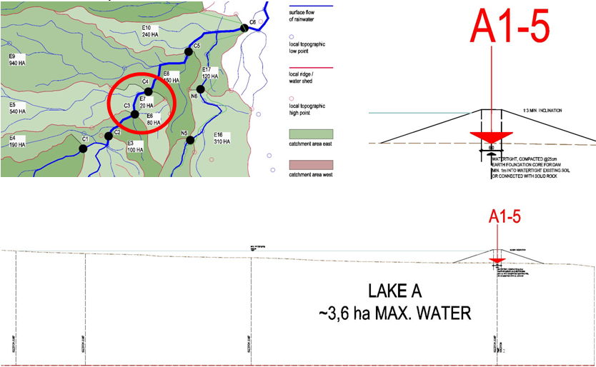
A precipitation catchment study was produced in to do some calculations for the dimensioning of the proposed prototype lakes of workzone 01.
The site is divided into a western and eastern part by a main water shed running from south to north.
The eastern part of the site looks more promising in terms of achieving good results with relatively little effort. Due to the natural existance of favourable microclimate zones in terms of varied canyon structures this area is also predestined to locate most of the dwelling and settlement structures there
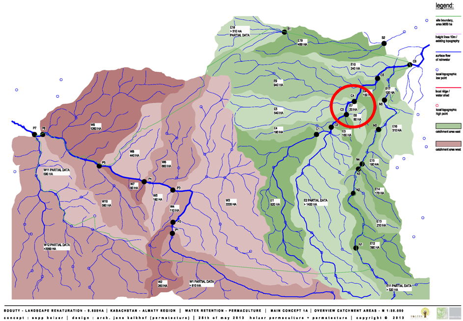
Most interesting is the spot indicated as "C4" on the catchment study on the eastern part. It is a narrow valley through which about 3.250ha of precipitation runoff (surface and underground) must flow.
If we assume a precipitation of 200l/m²/year, a total of 6,5 Mio. m³ of water will fall onto this catchment area in one year. Taking diverse runoff constants into account we could calculate roughly 10% of preciptation which will pass this narrow valley (above and below earth surface!).
This would amount to roughly 650.000 m³/year. That amount of water would theoretically fill a 6,5ha big lake that is 10m deep.
If we calculate evaporation rates of 1000mm/m²/year (= 1 m³/m²/year), the level of the lake would drop by 1m (10%) in the course of the first year.
In the second year 1m (10%) would be needed for refilling the lake, 1m (10%) would get lost through evaporation and 8m (80%) would have to leave the lake via the overflow.
In the third and following years the evaporation will be compensated directly (1m = 10%) and the rest will leave the lake via the "overflow" (9m = 90% = 585.000m³).
The "overflow" is a usefull and necessary aspect of lake bulding which can be constructed in numerous ways.
In rainwater retention systems within all arid climatic conditions (evapotranspiration > precipitation) it is of utmost importance that a flow-through of water is constantly provided. Excessive evaporation of open water surfaces will lead to a concentration of minerals in the stored water and its salinization levels will become intolearable after a while.
Prototype lake "A" – workzone 01
Generally, the existing geological conditions support the intitial concept of renaturation through the building of decentralised lake structures only using natural building materials available on the spot.
Four areas on the site were analysed specifically in terms of geological conditions, suitability of the soil and the presence and availability of ground water. These strategic spots were both defined during site visits as well as theoretical precipitation catchment studies. The most promising is lake "A" which is situated near spot "C4" of the catchment study. This should be the first lake to be constructed
Prototype lake "A" – Geological survey analysis
Aims
In the areas of the projected watertight dams of the lakes "A"-"D" five geological spot surveys were made to establish the following facts:
- a) presence and depth of ground water
- b) soil quality, availability and suitability / water tightness for building earth dams / construction of lakes
- c) depth of existing watertight layers, especially rock in order to calculate the construction effort
Results lake "A"
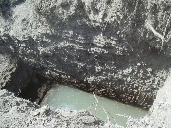
a) presence of moving ground water at about 4,63m below terrain. This ground water is moving slowly downhill (east), through the oil resistance its fluidity behaviour is more like "honey" than "water" underground; its level changes according to wet and dry periods. An underground watertight dam-barrier will prevent this water from disappearing and will store it visibly in the lake "A" and invisibly in the surrounding soil. Through the construction of an underground barrier the groundwater table will be raised in the uphill region of lake "A" and means an easy to tap water reservoir for the downhill areas
Lake building – general technical information in 8 "easy" steps
Step 01a : surveying, marking and demarcating the site roughly (just for removing and intermediately storing top layer soil).
Step 02 : removing and strategically storing top layer soil (~20cm thick, alternating according to natural conditions), i.e. using a bulldozer.
Step 01b : surveying, marking and demarcating the site for area of lake (earth dam boundary has been defined by steps 01a and 02 already).
Step 03 : excavating lake / building up earth dam and modelling it simultaneously, storing soil with high clay content separately, using excavator, trucks (min. 2 trucks) and bulldozer
Step 04 : building up and compacting watertight dam core barrier (around 6m thick in the middle of the dam staring from solid non-weathered rock) using suitable soil, compacting it in layers of 25cm each using vibrating compactor and taking great care of the quality of the work (the most important step). Existing ground water will have to be pumped out during building works. Apart from top soil, all other earth material can be used to shepe the dam on either side of the watertight inner core.
Step 05 : Implementing some "technical" details as necessary and required (i.e. bridges, fords, piping, tubing, electricity, manholes, ducts, irragation systems, etc.) .
Step 06: (re-) covering the whole building area with the stored top soil (step 02) as well as modelling terraces inside lake with top soil, also implementing some more "technical" details (i.e. bridges, fords, piping, irragation systems,etc.).
Step 07: sowing (i.e. green manure) and mulching to prevent erosion directly after step 05; planting trees, shrubs, bushes, herbs, etc. as soon as suitable climate conditions exist (i.e. trees autumn or spring, seeds any time)
Step 08 : waiting for rain and watching the groundwater fill up the lakes, enjoying the sucess and beauty of the project.
Reforestation
The following procedure must be adhered and kept to at all times in order to produce a successful project:
- Inquiry - the more research, thought and time is taken, the better.
- Planning (partially parallel to 1.; the current phase !),
- Building (the phase coming up very soon).
- Planting (the phase after building).
It is not at all possible to turn around the order of these phases. Each of those takes its time and should not been accelerated. In these climatic, water and soil condition one will not be able to just plant trees and shrubs on, let us say, 600 ha. They will die very quickly, the project will be a catastrophe!
Communication and learning from nature is the key: one will have to look at the effects of the proposed interventions and react accordingly. All one can do is to implement basic strategies that are known to work (many international projects and experience have proved this) and take it from there. The strategies will work but a constant contention with natural changing parameters and conditions is unavoidable.
- Inquiry and preconditions
Whilst in areas with a nourishing and stable soil reforestation may be easier, ecological conditions have to be considered very accurate when moving on degradated ground. The situation is never randomly, it comes as a consequence of misunderstanding and thus exploiting nature, so that natural rhythms and living circles cannot keep balance any longer. Those processes may be executed by humans over ages, nevertheless sometimes it only takes a couple of years to destroy well-balanced networks.
Note: The key to correct these wrongdoings is understanding natural rhythms and strategies by not making the same mistakes again and again. Nature has got an incredible potential of regeneration and self correction. Nevertheless large scale projects and impacts are comparable of destroying our own roots. The earth will deal with it; humans may not be able to face the changes.
- Planning
- Building
- Planting
Reforestation is a multi-step process, which has got to follow natural strategies for reconquest of irritated habitats. First of all the habitats have to have potential, that is meant in terms of climate, soil, geology, water conditions, solar radiation, wind and some more important factors, which are still not completely understood by todays research. Each factor influences each other and finally build a network which is well buffered.
The first step in reforestation is to ask if there has ever been forest or at least trees on a potential site. If it may be answered with a clear yes, one may “help” by enhancing situations by technical support as described above.
It is of high importance to carefully select where to interfere. Never should any hot spots be destroyed, which are usually recognizable by higher biodiversity, both on flora and fauna, not to forget fungi and microorganism. They build up the pool where any future life is based. These hot spots are of much higher significance than introduced plants and seeds, as they already exist as a working balance within a more or less hostile situation.
The existence of water on formerly dry land is a first success. In water-near areas plants will settle, while in more distant locations ground has to stabilized, which is usually done by the roots of plants (e.g. grasses like Agropyron or some species of Artemisia). Later on pioneers help in the process of consolidation whilst water consumption rises.
The period of time for such a succession mainly depends on climatic factors, fertility of soils, and peace of human impact of any kind. Strictly obeyed is the absence of any usage of such lands, except if advised by ecologists and planning team.
It is of utmost importance to get information of the availability of local seeds of all sorts (wild and cultured plants), produced in biological and/or natural way (i.e. preferred are "wild collections" of really suited and adapted species, as varied as possible).
Future Chapters:
Demarcation of valuable natural habitats....
Protection and screening of endangered species....
Drinking Water...
Agro – Ecology...
Animal keeping...
Settlement concepts...
Buildings / Infrastructure...
Pathway System...
Greenhouses...
Gardens...
Renewable and sutainable energy concepts
Due to the extremely dry air and great number of intense sunny days with high solar radiation the direct use of solar power systems can only be recommended.
Economical aspects...
Carbon emission funding: Planting and reforestation concepts - some thoughts
The project must be presented in a professional manner, well researched and documented in order to apply for any international funding. Any other approach would be frivolous and unsound. Besides, money that has already been granted could be reclaimed in the future if the project does not adhere to the initial contractual funding promises that were agreed upon.
At the moment, from our point of view, it is a little too early for these carbon emission funding applications because we have not got any prototypes yet in order to prove the working of the above concepts in the specific and difficult conditions of the site. These prototypes – various lakes as the basis for the creation of tessallated oases - will have to be created first:
- All experiments should take place on a relatively small scale in order to minimise work, risks and thereby time and costs.
- Everything must be documented professionally.
- Experience within this very specific site must be gained (and also the myriads of different local conditions there) as well as presenting a working master plan that takes the results of the experiments into account.
Definitely, it is a good idea to apply for international ecological funding and try out possibilities in this sector for co-financing this ambitious project.
Nonetheless: the project is a real prototype at the moment and it is impossible to quantify anything at this stage (i.e. how long it will take to produce a certain amount of m³ timber / ha / year). One does not know at the moment without trying and documenting! The soil will have to be built up and brought back to life as a precondition. First and foremost of all! For this process water is needed; lots of it! Systems with positive ecological feedback mechanisms will have to be created. These systems become more productive every year if set up and managed correctly.
Solely quantifying approaches are not permaculture! We do not ask the agricultural production yield per ha. This is not the way the permacultural approach works because some "yields" are not quantifyable. We believe in the reintroduction of stable ecosystems that are sustainable for many generations. What is the value of a frog, for example, who could not have existed on this site before this "artificial" intervention?
Nonetheless, this frog is also part of a complicated interdependant ecological network, which provides the basis of our existence. What is the monetary value of our existence base?
Bureaucratic and legal considerations...
Conclusion
In any case, the above concept presents a feasible solution for halting the continually spreading desertification of this sensible landscape as well as renaturing the existing steppe with sustainable means. This also implies a high quality of life for all inhabitants within this complex and difficult landscape.


